


前往爱尔兰阿伦群岛旅行时,eSIM 通常可以使用,但不要将爱尔兰大陆的体验作为整个旅程的标准。爱尔兰三大运营商的 4G 网络覆盖全国约 99% 人口。.
在岛上,码头、村庄和主要道路的信号通常足够好;但在悬崖小径、石堡和开阔的沿海地区,信号会显著减弱。渡轮航程大约需要 40 至 55 分钟,期间网络不稳定。最好提前下载导航、船票和离线地图。.
力量
能否在阿伦群岛顺利使用爱尔兰 eSIM 卡,首先取决于您所在的位置,而不是套餐页面。. 从罗萨维尔 (Rossaveel) 到伊尼什莫尔岛 (Inis Mór) 的渡轮大约需要 40 分钟,从戈尔韦市 (Galway City) 到伊尼什莫尔岛大约需要 90 分钟;一旦上了岛,与悬崖小路、海边遗址和偏远观景点相比,基尔罗南码头 (Kilronan Pier)、住宿区、餐馆和主要道路沿线的信号通常更稳定。.
公共旅游信息提到岛上互联网和电话信号很强,但这更接近于“在经常访问的地区正常使用”,而不是整个岛屿的统一水平。.
力量分布并不均匀。
如果将阿伦群岛的信号理解为“一下船就能在整个岛上听到相同的信号”,那就与实际情况有所偏差。这三个岛屿更靠近戈尔韦湾的开阔海域,大多数游客到达的第一个岛屿是 伊尼什莫尔岛; 官方记录显示,从罗萨维尔出发大约需要…… 40分钟 到伊尼什莫尔岛,大约 50分钟 到伊尼什梅恩岛,以及大约 55分钟 伊尼斯·奥尔。对于从戈尔韦市到伊尼斯莫尔的直达渡轮,公共时间表给出了 90分钟.
游客抵达后首先遇到的区域通常是 基尔罗南码头、自行车租赁、餐厅、旅馆以及主要道路沿线. 这些地方人流量更大,住宿和服务点也更多,因此日常上网、GPS定位、查看电子邮件和查询返程时间通常都比较顺畅。.
阿兰群岛渡轮的旅行提示页面甚至还包括 网络和电话信号都很强 在岛屿准备信息中,但这一说法更接近于“满足公共区域的基本需求”,而不是说岛上每一段石墙道路或每一处悬崖边缘都能保持相同的信号灯格和速度。.
将各个地点分开描述,会更贴近旅行者当天的真实感受:
| 区域 | 常见场景 | 典型经验 |
|---|---|---|
| 基尔罗南码头附近 | 打开地图、联系酒店、查询机票 | 页面加载速度更快,消息和语音通话更稳定 |
| 乡村餐厅和住宿带 | 上传照片、查看电子邮件、预订下一班车 | 足以满足日常使用,速度通常比偏远地区更快。 |
| 主干道自行车道 | 骑行导航 | 网络偶尔会重新连接,速度可能不稳定。 |
| Dún Aonghasa、黑堡、虫洞区域 | 拍摄视频、GPS定位、检查步行路线 | 更容易出现加载缓慢和图片上传延迟的情况 |
| 开阔的海岸线和悬崖边缘 | 发布实时内容,视频通话 | 更依赖于当时的网络连接和确切位置。 |
以上并非将岛屿划分为“连通的”和“不连通的”,而是划分不同的体验层次: 村庄和码头更像是标准的旅游区,而偏远景点更像是离岸自然区。.
阿兰群岛的公共旅游页面对伊尼斯莫尔的介绍也有助于判断这种差异。 Dún Aonghasa 被官方描述为 300英尺 悬崖边,场地面积约为 14英亩; 虫洞和黑堡也是热门旅游景点,但它们位于较为开阔的沿海地带。在这些地方,许多人会同时进行三件事:上网导航、拍摄视频和发布社交媒体内容。.
可以通过更具体的当日游行程安排来查看。.
早上从罗萨维尔乘船,抵达伊尼什莫尔岛。 40分钟; 下船后,在基尔罗南租一辆自行车,买瓶水,打开地图——前30分钟通常感觉最像“在城镇里上网”;当你向邓昂哈萨或虫洞方向移动时,地形、海风、石墙和开阔的景观都会发生变化,你的手机位置也会不断变化;在返回之前,当你回到码头、咖啡馆和旅游服务点时,加载速度通常会恢复到更流畅的状态。.
一天中信号不是只有“好信号”或“坏信号”两种状态,而是一种随着离开服务区进入更开阔的区域而逐渐变差的体验。.
看看网络运营商自己提供的覆盖范围声明:沃达丰爱尔兰公司表示 4G网络覆盖人口超过99% 在其网站上。这类数据具有参考价值,但它指的是 人口覆盖率, 而不是“覆盖海岸线的每一段”或“在每个近海观测点保持相同的信号强度”。沃达丰的另一份声明提到,这个数字是通过将爱尔兰人口分布图与4G信号覆盖图叠加计算得出的。.
换句话说,它主要解释了“有多少人居住在覆盖区域内”,但这并不意味着游客在走到悬崖边、古代堡垒遗址或海蚀地貌附近时一定会有同样的表现。.
这一点对于购买eSIM卡来说非常重要。.
游客还可以分为三种类型:
| 旅游类型 | 日常活动 | 信号强度要求 |
|---|---|---|
| 一日游游客 | 码头 + 村庄午餐 + 1-2 个景点 | 中等或标准的数据连接通常就足够了。 |
| 骑行游客 | 在主干道上行驶 + 多点停靠 + 导航 | 海拔越高,移动过程中重新连接就越常见。 |
| 内容创作者 | 视频拍摄+云备份+社交媒体上传 | 地势较高、位置偏远的地区需要更好的网络连接质量 |
如果您只是在码头附近接收验证码、联系住宿或查看返程时间,那么一张标准的爱尔兰 eSIM 卡通常就足够了;但如果您需要在 4 到 6 小时内不断切换位置、骑行时查看地图、拍摄后立即上传视频,并且需要与同伴保持联系,那么就不要把“在岛上有信号”等同于“全程一致的体验”。”
以下是一些有助于您安排行程的补充信息:阿兰群岛渡轮公司2026年时刻表页面列出了前往伊尼什莫尔岛的航班时刻表。在某些日期,从罗萨维尔出发的航班可能会有所变更。 08:15, 10:30, 18:00, 18:30 时间段;这表明游客的到达和返回将集中在有限的时间段内。.
由于码头和上下船高峰时段人流密集,本地网络体验往往更容易受到同时在线用户数量的影响。用户可能感受到的并非“完全没有网络”,而是购票页面加载速度稍慢、地图显示速度变慢或图片上传排队时间延长等情况。.
为了使文本更贴近实际场景,“强度分布”可以表述为以下简单的判断:
村庄、码头和住宿区更适合完成线上操作;偏远的海滨景点更适合先进行线下准备,然后再回到信号更稳定的地区处理上传和大文件。.
将此应用于出发前准备:
-
离线保存返程机票、酒店地址和紧急联系电话
-
提前下载地图,特别是伊尼什莫尔环线路线。
-
避免同时进行导航、拍摄和上传操作。
-
在像敦昂哈萨和虫洞这样的区域,照片和视频可以先保存到本地。
-
当需要向同伴发送你的位置信息时,为了更顺利地完成操作,请等到回到主干道或靠近村庄时再进行。
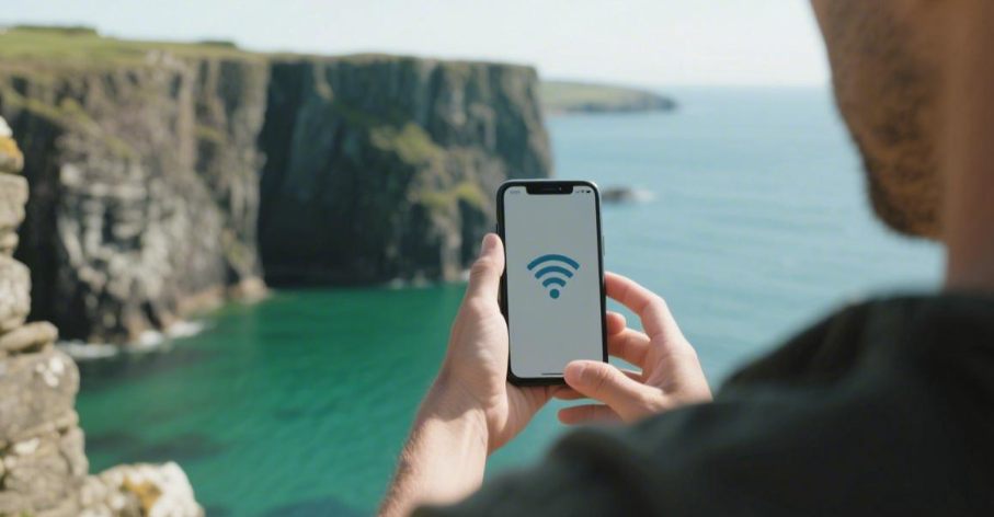
阿伦群岛由以下部分组成: 3 位于戈尔韦湾外海的离岸岛屿。官方旅游页面称它们大约 48公里/30英里 来自大陆。这种地理位置决定了移动信号更多地集中在码头、村庄和服务点附近,而不是像在大城市那样连续且几乎无缝。.
网络本身
一旦你抵达阿伦群岛,决定你体验的就不是你买了3GB、5GB还是10GB的流量,而是…… eSIM 连接到哪个爱尔兰网络,您的手机当前使用的是 4G 还是 5G 网络,语音通话是否通过 VoLTE 进行,以及设备是否能够稳定地保持在本地频段上。.
爱尔兰三大网络运营商的公开宣称的流量价格相当高:沃达丰表示 4G 人口覆盖率超过 99%; 他们的州 99.9% 4G 人口覆盖率, 同时提到其网络“在爱尔兰提供超过99%的4G覆盖”;Three States 99% 4G覆盖, 5G覆盖范围超过 94%.
此时,“人口覆盖率”和“您的当前位置”应分开查看。ComReg 的户外移动网络覆盖地图明确指出,用户可以按以下方式搜索: 地址、邮政编码或当前位置 预测户外覆盖率 2G、3G、4G 和 5G, 该地图将信号分为五个等级: 非常好、好、一般、边缘、无覆盖. 换句话说,在爱尔兰当地的监管语言中,医疗覆盖范围不是非此即彼的“是”或“否”,而是一个从“非常好”到“边缘”的连续差异范围。”
同一张 eSIM 卡在基尔罗南码头附近显示 4G 信号满格,然后骑车到更开阔的沿海地区后信号降至一般或边缘,这并不奇怪。.
监管机构提供的工具是按地点进行检查的,而不是按国家名称进行检查的。.
要分析网络本身,首先要看接入层。许多爱尔兰 eSIM 卡并不构建自己的网络,而是接入 Vodafone、eir 或 Three 等本地网络。岛上的用户体验通常根据以下四个条件而有所不同:
-
是否只允许使用单个网络,还是可以在多个本地网络之间切换
-
手机是否支持 4G通话/VoLTE
-
目前是否采用 4G/5G 而非旧标准
-
设备是否启用自动网络选择功能,或者是否可以手动重新选择网络
其中,VoLTE经常被忽视。沃达丰的网站明确指出:在3G网络关闭后,, 4G/5G手机 用户应启用 4G通话/VoLTE和VoWiFi 为了获得更稳定的连接;如果设备仍然依赖 3G 网络传输数据,那么在 3G 网络关闭后,服务将会受到影响。对于游客来说,这句话非常实用: 并非所有“支持 eSIM”的手机都能在更新的网络层上保持通话和数据传输。.
从3G网络情况来看,沃达丰的公开页面显示,其已完成3G网络关闭。 Limerick, Cork, Galway, and Dublin city, with further phased progress in 2024; the public pages of eir and Three focus on wide-scale 4G and 5G coverage.
The Aran Islands are offshore islands near Galway. If tourists are using older devices, or if the eSIM configuration does not set Voice & Data 到 5G/4G + VoLTE On, they are more likely to experience “having signal bars but the connection is not as smooth as expected” in offshore environments.
The differences in the network itself can be summarized in the following table which is easier to understand:
| Network Aspect | Common Terms on Pages | Real Experience Understanding on Island |
|---|---|---|
| 覆盖范围 | 99%, 99.9%, 94% | Mostly population or national totals, not equal to every offshore spot |
| 5G | every county / expanding / 615 towns and cities | County or town-level coverage, does not mean 5G is always on coastal paths |
| 4G通话/VoLTE | supported handset required | If device unsupported, voice and data switching is less smooth |
| Wi-Fi Calling | Calls possible during poor mobile signal | Only helpful in indoor locations with Wi-Fi |
| Auto-selection | Enabled by default | Convenient while moving, manual reselection can sometimes improve connection |
This table corresponds to the usage conditions written by Irish operators themselves, not theory. Vodafone’s public page states that 4G Calling requires a compatible device and suggests iPhone users set their Voice & Data in the eSIM settings to 5G/4G, VoLTE On; it also explains that Wi-Fi Calling allows calls to be made over Wi-Fi when the mobile signal is not strong enough.
Once on the island, the meaning of these two is very practical: when staying in guesthouses, restaurants, or near tourist centers, Wi-Fi Calling often helps with voice calls; once you leave indoors, it still comes down to 4G/5G and the local network itself.
On the island, not every instance of “average signal” means the network is bad.
Sometimes it’s because the phone doesn’t have VoLTE enabled, sometimes the device is stuck on a weaker network layer, and sometimes the eSIM only provides access to a single network.
Viewing the three major networks together makes the differences clearer. eir’s investor page mentions that its mobile network “offers more than 99% 4G coverage across Ireland” and as of December 2024, 5G outdoor population coverage reached 615 towns and cities from 1,720 sites; Three’s public page states its 4G coverage is 99% and 5G coverage exceeds 94%, with a market share of 48.7% as of March 2025 and nearly 5.1 million customers; Vodafone explains its 4G网络覆盖人口超过99% alongside VoLTE and Wi-Fi Calling settings following the 3G shutdown.
Now consider the types of eSIM themselves. Many travel eSIM pages say “available in Ireland” but do not clearly state the access method. For use on offshore islands, these two types differ significantly:
-
Single-network access: Attached to only one network; if the current spot falls into “good” or “fair,” there are no other local networks to try.
-
Multi-network access: Can switch between multiple networks automatically or manually, providing an extra layer of choice in fringe locations.
According to Vodafone’s setup instructions, the path to enable 4G Calling on an iPhone is Settings → Mobile Data → Mobile Data Options → Voice & Data → 5G/4G, VoLTE On; Android models usually require going into Connections / Mobile Networks to set the Network mode/type 到 5G/4G/LTE auto, and some models require separately turning on VoLTE / 4G Calling / Data Calling.
-
When looking at coverage figures: Distinguish first whether it is population coverage, outdoor geography, or specifically for towns/counties.
-
When looking at 5G: Confirm whether it refers to “all counties,” “615 towns and cities,” or “selected areas.”
-
When looking at voice: Confirm if the phone can use VoLTE / 4G Calling; do not assume “installing an eSIM equals smooth calls and data.”
-
When looking at packages: Prioritize finding out which local network it accesses and if switching is possible.
-
When looking at maps: Use the ComReg coverage map to check by specific locations on the island, not just the county name “Galway.”
On the Aran Islands, the difference in Ireland eSIMs usually doesn’t show up between 3GB and 10GB first, but rather which local network it connects to, whether your phone has 4G/5G and VoLTE turned on, and whether your current location is “very good,” “good,” or “fair” on the ComReg map. The performance of the same eSIM will naturally differ between the pier, guesthouses, main roads, and seaside paths.
渡轮
Before heading to the Aran Islands, clarify the ferry routes. The Rossaveel line serves all three islands year-round. Connecting from Galway City by bus takes about 50分钟. The ferry duration is 40分钟 to Inis Mór, 50分钟 to Inis Meáin, and 55分钟 to Inis Oírr. The Doolin line is shorter, taking only 15 minutes to Inis Oírr and usually 35 minutes to Inis Mór, but its 2026 operating period is listed as February 28 to November 1.
If you care about your eSIM experience, your on-board experience is determined by voyage length, distance from shore, schedule times, and departure connections.
渡轮航线
Before worrying about speed tests on the islands, distinguish the ferry lines. Common departure points are Rossaveel, Galway City, and Doolin. The Aran Island Ferries website states that Rossaveel to Inis Mór is about 40 minutes, to Inis Meáin 50分钟, and to Inis Oírr 55分钟; the seasonal direct flight from Galway City to Inis Mór is about 90分钟.
Doolin Ferry Co. reports shorter times: 15 minutes from Doolin to Inis Oírr, 25 minutes to Inis Meáin, and 35 minutes to Inis Mór. Even though both are “going to the Aran Islands,” the time spent at sea can differ by 50 to 75 minutes, and the experience of the eSIM on the boat will change accordingly.
Viewing the routes together makes comparison easier. Rossaveel serves three islands year-round; the Galway City direct ferry only goes to Inis Mór and is seasonal; Doolin is also not year-round, with the official site stating it operates from February 28 to November 1, 2026.
For those departing in March, November, December, or January, what looks like “choosing a port” is actually checking if there is a boat, if the same schedule exists daily, and if the return trip still connects to your accommodation.
| Departure | To Inis Mór | To Inis Meáin | To Inis Oírr | 2026 Ops |
|---|---|---|---|---|
| Rossaveel | 40 mins | 50 mins | 55 mins | Year-round |
| Galway City | 90 mins | — | — | Seasonal |
| Doolin | 35 mins | 25 mins | 15 mins | Feb 28 – Nov 1 |
These figures are very telling: if you live in Galway City but don’t want to spend 90分钟 at sea, it’s not as simple as “Galway City boarding is more convenient.” You have to decide whether to take the shuttle to Rossaveel to reduce the time at sea from 90 minutes to 40 minutes. The route itself determines not just arrival times, but the duration your phone spends in weak coverage areas over the sea.
Divide them by departure environment first:
-
Staying in Galway City, no rental car: Priority is usually Galway shuttle bus + Rossaveel
-
Staying in Clare, Doolin, or Lahinch area: More likely to put Doolin first
-
Traveling in winter or shoulder season: Check Rossaveel first, as it’s year-round
-
Only going to 伊尼什莫尔岛 and want to board from the city pier: Only then compare the Galway City direct ferry
ComReg’s Irish outdoor mobile coverage tool explains that it shows predicted outdoor coverage, classified into levels like very good, good, fair, and fringe. This phrasing serves as a reminder: the longer the ferry route, the longer the phone is away from shore-based stations.
This means the 90-minute sea route from Galway City is naturally more likely to encounter sections where you can only send text and cannot open images; Doolin–Inis Oírr 15 minutes is more like a short crossing—even if it drops to weaker coverage, you’ll be docking soon.
For first-time visitors, the following judgments are more practical:
-
Living in Galway without a car, look at Rossaveel + shuttle first
-
Living in Doolin / Clare for a half-day or day trip, look at Doolin first
-
If the trip is in winter, rule out the Doolin seasonal route first
-
If you need to complete verification codes, payment pages, or map refreshes en route, try to shorten the time at sea
Behind these judgments are clear numbers: a 12-hour shuttle booking requirement, a 20-minute early arrival requirement, different ferry durations of 15 / 25 / 35 / 40 / 50 / 55 / 90 minutes, and the February 28 to November 1 Doolin operating window. Reviewing these before choosing an eSIM and island arrival method will make things much smoother.
板载使用
Once the ferry leaves the pier, the eSIM experience is no longer just about “whether the package is enough,” but a very specific process of usage at sea. It typically takes 40分钟 from Rossaveel to Inis Mór, 50分钟 to Inis Meáin, and 55分钟 to Inis Oírr; Galway City to Inis Mór takes about 90分钟; Doolin to Inis Oírr is 15 minutes, to Inis Meáin 25 minutes, and to Inis Mór 35 minutes. Although they are all ferries, the longest time at sea can differ by 75 minutes, so the feeling of mobile connectivity will naturally vary.
ComReg’s Irish outdoor mobile coverage map clearly states that it shows predicted outdoor coverage, with coverage levels divided into 非常好、好、一般、边缘、无覆盖. Furthermore, it is an outdoor prediction, not a point-by-point guarantee on the boat.
Seeing 4G/5G at the Rossaveel, Galway, or Doolin piers does not mean that same state will hold midway through the trip. This sea segment is inherently more dependent on shore stations; the further the boat is from land, the more common it is for the phone to switch between different signal levels.
Breaking down the time spent on the boat makes it closer to daily usage. During the first 5–10 minutes after leaving the port, the phone is still close to land, so map refreshing, message synchronization, and email reception are usually smoother; in the middle section at sea, especially during longer crossings of 40–90 minutes, it is easier for images to load slowly, speed tests to drop, and apps to keep buffering; in the last 5–10 minutes before docking, as the phone gets closer to the island’s base stations, messages and notifications often catch up all at once.
This rhythm varies significantly between short and long routes. On the 15-minute Doolin–Inis Oírr route, you often dock before even feeling any inconvenience; on the 90-minute Galway City–Inis Mór route, it is more necessary to save your information in advance.
| Route | Common Official Duration | General Feel of Mid-crossing Length | Better Tasks to Do on Board | Tasks Not Suitable for on Board |
|---|---|---|---|---|
| Doolin → Inis Oírr | 15 minutes | Very short; low-speed mid-section is usually brief | Read text messages, check cached maps | Video calls, uploading large temporary files |
| Doolin → Inis Meáin | 25 minutes | Brief mid-section present | Check emails, view offline itineraries | On-site payment verification, multi-image downloads |
| Doolin → Inis Mór | 35 minutes | Mid-section is more noticeable | Light browsing, simple searches | Hotspot sharing, voice meetings |
| Rossaveel → Inis Mór | 40分钟 | Mid-section is perceptible | Text navigation, logged-in app operations | First-time logins, verification code operations |
| Rossaveel → Inis Meáin | 50分钟 | Longer mid-section | Check local info, view screenshots | Upload videos, cloud photo synchronization |
| Rossaveel → Inis Oírr | 55分钟 | Mid-section lasts longer | Offline reading | Payments and forms requiring real-time network |
| Galway City → Inis Mór | 90分钟 | Longest mid-section | Offline maps, notes, screenshots | Live streaming, stable hotspots, cloud backups |
The table above is not a functional description from the ferry company, but an arrangement that is closer to daily usage after combining the official sailing times with ComReg’s coverage representations. The longer the route, the less suitable it is to leave tasks requiring continuous network connectivity for the boat.
Many people’s first reaction upon boarding is to test their speed, but it is actually more useful to categorize tasks first. For example, boarding emails, return ticket QR codes, B&B addresses, car rental phone numbers, offline maps, and weather pages—of these, very few actually require a real-time network.
Most ferry pages already provide schedule information; Rossaveel operates the three-island route year-round, and the Doolin website specifies daily sailing times and seasonal ranges. Travelers can completely screenshot these pages 10分钟 before departure instead of waiting until the middle of the sea to open them.
You can categorize by usage intensity like this:
-
Only viewing maps or text messages: 1–5MB level, usually no major pressure on the boat
-
Scrolling short videos or viewing high-resolution images: dozens of MBs will be used up quickly, making lag more likely on long routes
-
Turning on a hotspot for a second device: Once two devices request data simultaneously, speed is more likely to drop under weaker coverage
-
Video calls: Even for only 10–15 minutes, these require higher continuous upload and download speeds
-
Receiving verification codes on-site: Best done before departure or before docking; not suitable for the mid-section
This is why, even with the same Ireland eSIM, some people find it “usable” while others find it “constantly buffering.” The difference often lies not in the plan name, but in what operations you perform during which period.
ComReg uses the term predicted outdoor coverage, not guaranteed onboard coverage. For scenarios like ferries, reading this term itself is enough: it is better for judging general trends, not for expecting the same speed to be maintained throughout the journey.
If you factor in seating and position on the boat, the experience will feel different. People sitting by windows or near the outer deck sometimes find it easier for their phones to catch a stronger signal; positions inside enclosed cabins or near the middle/rear of the hull typically have poorer reception conditions than open-air areas.
There is no official promise of “which seat on the boat is stronger,” but based on basic mobile signal propagation conditions, having one less layer of obstruction is usually more beneficial. This is one reason why many tourists feel “it was still working when I just came out, but images slowed down after entering the cabin.” This doesn’t mean the cabin is unusable, but that different positions on the same route will bring about some differences; on routes of 35–55 minutes, this difference will be more easily felt.
The following set of arrangements is closer to daily life:
-
Before boarding: Screenshot the ferry booking, return schedule, and accommodation address first
-
5 minutes before departure: Complete payment verification, check email, and receive verification codes
-
Mid-crossing: Only do things with low network dependence, such as viewing offline maps, text messages, or itineraries
-
5–10 minutes before docking: Refresh the map once more and send messages to accommodation or pickup parties
-
After docking: Upload photos, open hotspots, and view pages requiring continuous loading
This isn’t meant to make being on the boat sound troublesome, but rather to look at different sailing times like 15, 25, 35, 40, 50, 55, and 90 minutes in real-world usage. Short crossings have high tolerance, while long crossings rely more on advance preparation.
Another practical point: a signal dropping to 1–2 bars on the boat does not mean there is a problem with the eSIM. As long as your Ireland eSIM has already successfully registered on the network locally in Ireland, slow web pages, image delays, and social software reconnecting during the mid-crossing are often simply because it is further from shore, temporarily moving from very good / good into the fair or fringe range. Once the boat nears Inis Mór, Inis Meáin, or Inis Oírr, the connection often restores faster than you might expect.
For first-timers, the easiest approach usually involves just a few steps: for short routes, prioritize leaving real-time operations for the pier; for long routes, prioritize making content offline; tasks that can be completed at the port should not be left for the middle of the sea; and tasks requiring a continuous network for over 10 minutes should be saved for after arriving on the island.
时刻表和换乘信息
When going to the Aran Islands, many people look at the sailing time first, but schedules and transfers are more likely to affect the day’s arrangement. The Aran Island Ferries 2026 page states that direct sailings from Galway City to Inis Mór depart daily at 9:30, with a sailing time of approximately 90 minutes; Rossaveel operates year-round and has timetables for all three islands.
For those living in Galway city center, it’s not just a simple matter of “which pier to choose,” but a trade-off between saving transfers by boarding in the city 和 shorter time at sea. The Galway City pier saves on land transfers, but requires about 1.5 hours at sea; although you have to go to the port for Rossaveel, the trip to Inis Mór commonly takes only 40分钟.
The advantage of the Rossaveel route is first reflected in its year-round availability. The 2026 Inis Mór timetable shows there are fixed sailings from January 1 to April 2, with common departures at 10:30 and return trips commonly at 08:15 and in the evening; from June 27 to August 30, departures increase to denser combinations such as 10:30, 11:45, 13:00, and 18:30, with multiple return options at 09:00, 12:00, 16:00, and 18:30.
The logic at Doolin is different. The official website states its Aran Islands sailings run from February 28 to November 1, 2026; common departures listed on the Inis Oírr page are 10:00, 11:00, 13:00, and 15:00, , 和 17:15 available on some weekends; for Inis Mór, common times are 09:00, 11:00, and 15:00, but schedules are more complete from April 4 to August 30 and reduced during the shoulder seasons.
For those staying in the Clare area wanting a day trip, Doolin’s advantage is speed and sufficient frequency during the tourist season; however, if your trip falls after November or you need to manage your island time precisely, you cannot just look at the single figure of “35 minutes to Inis Mór.”
Clarifying the three connection methods first makes choosing easier:
| 方法 | Common Starting Point | 2026 Time Info | Suitable Itinerary Type |
|---|---|---|---|
| Galway City Direct | Galway City Docks | Daily at 9:30, approx. 90 mins to Inis Mór | Staying in the city, no desire for further transfers |
| Galway City Shuttle to Rossaveel | Board at Victoria Place | Shuttle must be booked at least 12 hours in advance; arriving 20 mins early suggested | Staying in the city, want to shorten time at sea |
| Doolin Direct | Doolin Pier | Seasonal operation, Feb 28 to Nov 1 | Staying in Clare, want to minimize crossing |
In the table above, the most easily overlooked part is the transfer restrictions. The Aran Island Ferries website specifies that the shuttle bus from Galway City to Rossaveel must be booked at least 12 hours in advance, and passengers are advised to arrive at the Victoria Place boarding point 20 minutes early; the booking page also notes that the shuttle bus cannot carry bicycles. If you only remember to switch to Rossaveel the night before, or decide to bring a bike that morning, it will likely be too late.
You can look at it based on your starting point:
-
Staying in Galway City centre without a rental car
-
Easier to choose between Galway City Direct 和 Galway shuttle + Rossaveel
-
The former has fewer transfers, the latter usually saves 50分钟 at sea
-
-
Staying around Doolin / Lahinch / Ennis
-
Better to look at Doolin first
-
15 minutes to Inis Oírr, making day trip pressure slightly lower
-
-
Itinerary falls in winter or after November
-
Doolin seasonal service is no longer a standard option
-
Rossaveel’s year-round schedule is more relevant
-
These judgments align with public timetables and are not chosen by mere feeling.
Galway City Direct saves one land transfer; Rossaveel saves time spent at sea; Doolin saves on crossing length, but is not available year-round. These three “savings” are in different areas.
Looking closer, the distribution of sailings is more important than the total number of sailings. The Rossaveel Inis Mór timetable spreads departures across morning, noon, and evening in the summer; this is very useful for day trips, as you can choose an early start like 09:30 bus / 10:30 ferry, or a later one like 12:00 bus / 13:00 ferry. In contrast, the Galway City Direct page lists one daily departure at 9.30am.
The same logic applies to the return journey. The Doolin to Inis Mór page shows common return times as 09:50, 12:00, 16:15; Inis Oírr to Doolin returns are commonly 10:30, 12:30, 13:45, 16:45. If you need to catch a bus to Limerick, Ennis, or back to Galway on the same day, your return arrival time will affect your onward land connections. The return journey is not just about “finding any boat,” but seeing whether it lands at noon, before 4 PM, or after evening.
Here is a set of practical judgments:
-
Staying only in Galway and don’t want to drive: first compare Galway direct sailing with shuttle + Rossaveel
-
Staying in Clare for only half a day to a day: prioritize Doolin
-
Traveling in December, January, early February: prioritize Rossaveel timetable
-
Need same-day round trip with long-distance bus connections: check return schedule first, then outbound
-
Need to bring a bike: first rule out the Galway shuttle segment restriction
There is also a practical difference: different target islands have different schedule structures. The Galway City direct sailing page emphasizes 伊尼什莫尔岛; the Rossaveel timetable is split into three islands; Doolin lists schedules for Inis Oírr and Inis Mór separately. If your destination is Inis Meáin, the city direct sailing itself is not the standard answer, and you usually end up back at Rossaveel; if the target is Inis Oírr, Doolin’s 15 minute crossing is more attractive.
远程站点
Whether Ireland eSIM can be used at remote points on the Aran Islands usually depends not on “is there a signal on the island,” but on how far you are from the main village, pier, roads, and visitor service points.
The Visitor Centre at Dún Aonghasa on Inis Mór is about 8 km from Cill Rónáin pier, and it’s another 1 km walk on rough gravel paths to the fort; for The Wormhole, the common route involves cycling for 15–30 minutes followed by a 10–15 minute walk.
These sites are closer to sea cliffs, limestone highlands, and the edges of the island; common eSIM performance involves having network but with slower speeds, unstable uploads, and map refresh delays.
ComReg’s coverage map only marks outdoor predicted coverage, categorized into five levels: very good, good, fair, fringe, and no coverage.
地点有多远
When evaluating Ireland eSIM on the Aran Islands, don’t just look at “Covers Ireland” on the package page. A more useful reference is how far your intended location is from the pier, main village, restaurants, accommodation, and bike rentals. The Aran Islands do not have a uniform network environment as soon as you step on shore.
Inis Mór is the largest of the three; official data states it is approximately 8 km long, about 2 km at its widest, 500 m at its narrowest, with a permanent population of about 800 people. Looking at these numbers together makes it easier to understand: the island isn’t huge, but tourist activity areas are not evenly spread; most service points are still concentrated around Kilronan / Cill Rónáin, and the further you go toward remote attractions, the more likely the network experience will differ from when you disembarked.
Many people feel a slight discrepancy after arriving. After the ferry docks, the Kilronan area has B&Bs, cafes, bike rentals, and common tourist services where loading maps, checking emails, or opening ticket QR codes is usually smooth.
The issue arises later: popular spots like Dún Aonghasa, The Wormhole, and Seven Churches are not right next to this main activity zone. Being on the island doesn’t mean you are still within that “service-dense” circle.
Take Dún Aonghasa first. The official page is clear: the fort itself is about 1 km from the Visitor Centre, involves an uphill approach, and the final stretch is rough, natural rock; another island resource notes the Visitor Centre is about 8 km from Kilronan.
Putting these two numbers together describes the actual route: depart from the pier, cross a major island road, reach the Visitor Centre, and finally walk about 1 km into an area closer to the sea cliffs. In other words, moving from “shops, houses, cars, and people” to “scenery and cliffs” happens in three distinct stages.
Now look at The Wormhole. Official times are split into two parts: by e-bike, it takes about 15–20 minutes to the end of the road, then another 10–15 minutes walking; by regular bike, it’s about 20–30 minutes to the road end, plus a 10–15 minute walk.
This time structure is more useful than just saying “how far an attraction is from the pier,” because it tells you that the final stretch standing by the attraction is not by a road or shop, but walking toward the sea on uneven ground.
You’ll find that while it looks close on a map, the site is actually outside the main activity zone. For eSIM, this “last 10 to 15 minute” difference is often more noticeable than the previous 20-minute ride.
Seven Churches is even better for judging “remoteness.” Official descriptions don’t mince words, stating it is located in a remote area of Inishmore. For tourists, a remote area doesn’t just mean “quieter scenery,” but also means you shouldn’t expect the same conditions as near the pier when using your phone.
For example, if you haven’t prepared your ticket QR code, accommodation phone number, or offline maps before leaving, trying to find emails or load map layers at these points will feel much slower.
Looking at common locations together makes it easier to judge the degree of distance from the main activity zone:
| 地点 | Island | Relation to Pier/Village | Official Time/Distance | On-site Environment |
|---|---|---|---|---|
| Kilronan / Cill Rónáin | 伊尼什莫尔岛 | The main activity zone itself | Ferry arrival point | Concentrated B&Bs, dining, rentals |
| Dún Aonghasa Visitor Centre | 伊尼什莫尔岛 | Away from the main village | Approx. 8 km from pier | Visitor services exist, but not pier environment |
| Dún Aonghasa Fort | 伊尼什莫尔岛 | Closer to sea cliffs | Additional 1 km walk | Rough rock, uphill, seaside |
| The Wormhole (Road End) | 伊尼什莫尔岛 | Far from main village | Cycle approx. 15–30 minutes | End of transport, switch to walking |
| The Wormhole (Site) | 伊尼什莫尔岛 | Coastal rock zone | Another 10–15 minute walk | Seaside, uneven ground |
| Seven Churches | 伊尼什莫尔岛 | Officially “remote area” | No uniform service dense zone | Closer to far-end ruins |
Another easily overlooked point: “Arriving at the attraction” does not mean “Arriving where phone use is smoothest.” Bikes for Dún Aonghasa are usually parked near the Visitor Centre, then everyone walks up; same for The Wormhole from the road end. This means the point transport can reach is often just the “start of the final walk,” not where you eventually take photos, look at the sea, or check locations.
For eSIM-dependent tourists, this walking segment is worth looking at separately because the time you are most likely to take out your phone is often precisely when you are further out, more exposed, and further from service points.
The same logic applies to Inis Oírr. Official records show this island is about 3km × 3km and can be covered by foot or bike, with the main village by the beach. The small area might suggest “village and remote ends aren’t much different,” but from a network perspective, differences still exist. While the village area is a hub for accommodation and daily activity, once you walk to the lighthouse, the Plassey shipwreck, or island ends, conditions become closer to “trail end” rather than “village center.”
Breaking down common usage scenarios helps clarify why “distance” matters:
| Phone Activity | In Main Activity Zone | Far from Main Zone |
|---|---|---|
| Opening Google Maps | Maps and routes load normally | Layers load slower, refresh takes longer |
| Finding Ticket QR | Email/App switching is smooth | Attachments load slowly, switching is laggy |
| Sending Text Messages | Mostly no pressure | Usable, but longer send times |
| Sending Photos/Videos | Usually smooth near village | Upload queues are common |
| Real-time Video Call | Depends on current network | More likely to drop at remote points |
These differences don’t wait for “no signal” to appear. Often the signal icon remains and pages aren’t completely unopenable; it’s just that an operation taking 3 seconds near the pier might take 15, 30, or even a retry at a remote point.
So when considering eSIM for the Aran Islands, rephrase “can it be used on the island” to: Am I staying near Kilronan, or cycling 20–30 minutes to Dún Aonghasa and walking 15–20 minutes up to the fort? Am I continuing to The Wormhole with another 10–15 minute walk into the rock zone? Am I planning for Seven Churches, which is officially a remote area? Once phrased in terms of distance and time, the eSIM experience difference becomes clear.
If your itinerary includes these further points, preparing offline maps, ticket QR codes, accommodation addresses, and contact numbers before you set off is safer than checking “how is the signal today” after arrival. The difference on the Aran Islands isn’t just “online” or “offline,” but a gradual shift from “immediate use” to “usable, but with a wait” as you move away from the main activity zone.
地形与海岸环境
On the Aran Islands, the difference in Ireland eSIM performance is often not about the data plan or phone model, but where you are standing, how close you are to the sea, and the surrounding stone walls and undulating terrain. Official sources describe the islands’ geography clearly: dominated by rugged limestone formations, meaning vast exposed limestone pavement, fissures, low stone walls, and open coastlines.
For tourists, this terrain doesn’t mean “no network on the whole island,” but that your experience can change within a few hundred meters on the same road. Opening a map in the village takes 2-3 seconds; by the rock pavement, a slope, or a cliff edge, it might take over 10 seconds, with photos and videos queueing for upload. ComReg’s official coverage maps don’t show signal as a single state, but divide it into five levels: very good, good, fair, fringe, no coverage, indicating that outdoor usage has distinct layers.
Listing the most common on-site differences helps clarify why “it looks the same on a map, but feels different in use”:
-
Around villages, piers, and accommodations, buildings and stop points are concentrated; checking email, maps, and receiving OTPs is usually smoother. This matches public data showing tourist activity is focused in the main village area.
-
Toward Dún Aonghasa, official sources state the final stretch is rough, natural rock with an uphill path. When the ground is rough and uneven, tourists are more likely to stop and start; the phone repeatedly refreshing location during movement will feel slower than in the village.
-
The common route for The Wormhole involves a 15–20 minute walk on uneven ground along the coast. When you actually take out your phone for photos, navigation, or messaging, you are usually away from the road.
-
ComReg coverage icons represent predicted outdoor coverage, not that “every rock, slope, or stone wall is identical.” The most common tourist scenario isn’t a total blackout, but pages opening with significantly slower load speeds.
Terrain itself splits the experience into layers. The Aran Islands are famous for limestone pavements. While looking open, it’s not a flat airport runway; it’s natural ground with cracks, rises, stones, and low walls. Moving on this ground changes your posture, phone angle, and standing position; without continuous shops or buildings as anchors, you tend to check your phone more frequently while moving.
The coastal environment adds another layer. Dún Aonghasa officially has a drop of about 87 meters with no perimeter fencing; another Heritage Ireland source describes it as nearly 90 meters and notes a 20 minute uphill walk from the Visitor Centre. The practical impact isn’t height itself, but being on the island’s edge facing the North Atlantic, surrounded by wind, cliffs, and fewer man-made facilities.
Operations here aren’t just browsing simple webpages; they are photography, video, maps, location sharing, and messaging. If throughput drops a notch compared to the village, you’ll feel it immediately. Text might send, but a 10-photo bundle, 30-second video, or video call will likely struggle.
Putting these differences into common routes makes it more intuitive:
| 设想 | Public Conditions | Common Phone Experience |
|---|---|---|
| Pier or Village Area | Concentrated services and crowds | Maps, email, QR codes usually smooth |
| En route to Dún Aonghasa | Uphill, final 1 km is rough natural rock | Positioning refreshes slower than flat roads; switching apps involves waiting |
| Cliff Edge Viewpoints | 87–90m drop, open sea facing | Uploading photos/videos and calls depend heavily on local signal |
| The Wormhole Walk | Approx. 15–20 mins on uneven ground | Maps usable, but not suitable for high-traffic reliance |
Stone walls and low-lying path segments also create differences. Iconic stone walls and rocky ground mean tourists frequently stop, turn, descend, and re-check maps. ComReg’s five-tier outdoor coverage confirms that different outdoor spots won’t have identical levels; their FAQ even admits that actual user experience may vary from the map display.
We can divide the most common location differences into three groups:
-
Open Flat Sections: Map loading is fastest, positioning stays continuous; best for pre-loading the next stretch. This aligns with ComReg’s outdoor coverage logic.
-
By Walls, Turns, or Hollows: Where tourists most frequently stop for photos or navigation; page refreshes are often slower than previous sections. Official per-point testing isn’t available, but FAQs warn of variance.
-
Cliff and Rock Edges: High wind, shorter stays, high multitasking (video, location, switching apps); any throughput drop is amplified. This is supported by public routes for Dún Aonghasa and The Wormhole.
Finally, many underestimate the gap between the Visitor Centre and the attraction itself. Dún Aonghasa is about 1 km from its Visitor Centre on an uphill path. Smooth browsing at the center doesn’t guarantee the same at the fort edge. The center is a service node, the fort a natural node; though only 1 km apart, that kilometer involves changes in ground material, elevation, and proximity to the open ocean. This “last kilometer” difference is often more impactful for tourists than the preceding 20-minute cycle.